Le Havre
|
Le Havre
|
 |
.svg.png) |
|
|
|
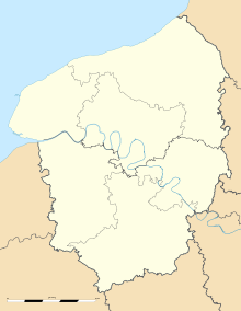
Location within Upper Normandy region
|
| Administration |
| Country |
France |
| Region |
Upper Normandy |
| Department |
Seine-Maritime |
| Arrondissement |
Rouen |
| Intercommunality |
CODAH |
| Mayor |
Antoine Rufenacht (UMP)
(2008 - 2014) |
| Statistics |
| Land area1 |
46.95 km2 (18.13 sq mi) |
| Population2 |
179,751 (2007) |
| - Ranking |
12th in France |
| - Density |
3,829 /km2 (9,920 /sq mi) |
| Urban area |
182.45 km2 (70.44 sq mi) (2006) |
| - Population |
246,195 (2006) |
| Metro area |
615.39 km2 (237.60 sq mi) (2006) |
| - Population |
291,765 (2006) |
| Time zone |
CET (UTC +1) |
| Website |
www.ville-lehavre.fr |
| 1 French Land Register data, which excludes lakes, ponds, glaciers > 1 km² (0.386 sq mi or 247 acres) and river estuaries. |
| 2 Population sans doubles comptes: residents of multiple communes (e.g., students and military personnel) only counted once. |
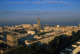
Le Havre (French pronunciation: [lə avʁ]) is a city in the Seine-Maritime department of the Haute-Normandie region in France. It is situated in north-western France, on the right bank of the mouth of the river Seine on the English Channel. Le Havre is the most populous commune in the Haute-Normandie region, although the total population of the greater Le Havre conurbation is smaller than that of Rouen's. It is also the second largest subprefecture in France (after Reims). Its port is the second busiest in France (after that of Marseille). Since 1974 it has been the see of the diocese of Le Havre.
Le Havre was originally named Franciscopolis after King Francis I, who founded the city in 1517. A chapel known as Notre-Dame-de-Grâce ("Our Lady of Grace") existed at the site before the city was established, and the denomination lent its name to the port, to be called Le Havre (or Le Hable) de Grâce ("the harbor of grace"). The shortened name Le Havre, as used in modern times, simply translates as "the port" or "the harbor".
While under German occupation, the city was devastated in 1944 during the Battle of Normandy in World War II; 5,000 people were killed and 12,000 homes destroyed, mainly by Allied air attacks. After the war, the center was rebuilt in the modernist style by Auguste Perret. Le Havre was honored with the Legion of Honor award on 18 July 1949. It was designated a UNESCO World Heritage Site in 2005.
Le Havre was once synonymous with urban gloom and greyness. The city's inhabitants have done much to change this; as a result of substantial improvements, Le Havre is now spoken of as the Brasilia of France. .
Le Havre's home port code is LH.
History
The name Le Havre simply means the harbour or the port. Le Havre was founded as a new port by royal command, partly to replace the historic harbors of Harfleur and Honfleur which had become increasingly impractical due to silting-up. The city was founded in 1517, when it was named Franciscopolis after Francis I of France, and subsequently named Le Havre-de-Grâce ("Harbor of Grace") after an existing chapel of Notre-Dame-de-Grâce ("our Lady of grace").
In the 18th century, Le Havre began to grow, as trade from the West Indies was added to that of France and Europe. In 1759 the city was the staging point for a planned French invasion of Britain - thousands of troops, horses and ships being assembled there - only for many of the barges to be destroyed in the Raid on Le Havre and the invasion to be abandoned following the naval defeat at Quiberon.
On 19 November 1793, the city changed its name to Hâvre de Marat and later Hâvre-Marat in honor of the recently deceased Jean-Paul Marat, who was seen as a martyr of the French Revolution. By early 1795, however, Marat's memory had become somewhat tarnished, and on January 13, 1795, the town's name became simply Le Havre.
During the 19th century, it became an industrial centre.
The German-occupied city was devastated during the Battle of Normandy in World War II: 5,000 people were killed and 12,000 homes were totally destroyed, mainly by Allied air attacks. Despite this, Le Havre became the location of one of the biggest Replacement Depots, or "Repple Depples" in the European Theatre of operations in WWII. Thousands of American replacement troops poured through the city before being deployed to combat operations.[1] After the war, the centre was rebuilt in modernist style by Auguste Perret. It was designated a UNESCO World Heritage Site in 2005. UNESCO declared the city center of Le Havre a World Heritage Site on 15 July 2005, in honoring the "innovative utilization of concrete's potential." The 133-hectare space that represents, according to UNESCO, "an exceptional example of architecture and town planning of the post-war era," is one of the rare contemporary World Heritage Sites in Europe.
Heraldry
|
|
The arms of Le Havre are blazoned :
Gules, a salamandre argent crowned and on flames Or, on a chief azure, 3 fleurs de lys Or, and on a franc-canton sable a lion Or armed and langued gules
|
Arms of Le Havre under the 1st Empire.
|
The Arms of Le Havre under the 1st Empire.
|
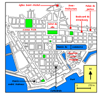
Geography
Le Havre is the second largest subprefecture in France, and the administrative center of the district bordering the Sainte-Adresse commune.
Location
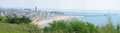
View of the beach of Le Havre and a part of the rebuilt city
Le Havre is situated in the southwest of the Pays de Caux region. The city is bordered by the seashore of the English Channel to the west, the mouth of the Seine to the south, and the coast to the north. Historically, the Seine marked a natural boundary between Haute-Normandie and Basse-Normandie; the city of Honfleur has often been referred to by the Havrais as being "on the other coast." As a port city on an exposed marshy coast, Le Havre has long suffered from poor land links. New road connections have been built since; among the most notable is the Pont de Normandie, which connects the two banks of the Seine and reduces traveling time between Honfleur and Le Havre to less than 15 minutes.
Geography
Le Havre is naturally separated into two areas by a cliff.
- The ville basse, or lower city, comprises the port, the city center, and the peripheral regions. It was constructed on the ancient marshlands which were drained in the 16th century. The soil is composed of alluvium deposited by the river Seine. The city center, reconstructed after World War II, stands on approximately a meter (3.3 ft) of flattened rubble.
- The ville haute, or upper city, is composed of "sensitive urban areas" or ZUS (Mont-Gaillard, Caucriauville, and Mare-Rouge [1]). The wealthy north-west region of the upper city (Sainte-Adresse and Dollemard) is the highest in altitude (between 90 and 115 meters.)
A road tunnel and funicular railway ease transport between the lower and upper cities.
Climate
| Climate data for Le Havre |
| Month |
Jan |
Feb |
Mar |
Apr |
May |
Jun |
Jul |
Aug |
Sep |
Oct |
Nov |
Dec |
Year |
| Average high °C (°F) |
6
(43) |
6
(43) |
8
(46) |
10
(50) |
13
(55) |
16
(61) |
18
(64) |
18
(64) |
17
(63) |
13
(55) |
9
(48) |
7
(45) |
12
(54) |
| Average low °C (°F) |
3
(37) |
3
(37) |
5
(41) |
7
(45) |
10
(50) |
12
(54) |
15
(59) |
15
(59) |
13
(55) |
11
(52) |
7
(45) |
5
(41) |
9
(48) |
| Source: [2] |
Demographics
The population of the Le Havre commune had 190,905 inhabitants in 1999, which makes it the 12th most populous city in France and the most populous in Haute-Normandie (although the total population of the greater Le Havre conurbation is smaller than that of Rouen's). It has seen a drop in population, particularly from 1975 to 1982; during these years of industrial crisis the population fell by 18,494. During the 1980s the population continued to decrease, though less rapidly. Le Havre's city limit had a population of 248,547 in 1999 (25th in France) and the urban area had a population of 296,773. With 20% of the population less than 20 years old, the city of Le Havre is relatively young, even though the population is shrinking. The foreign-born population is estimated at 8,208, 4.3% of the population, also with a tendency to diminish. Due to the economic changes that had affected the city, the CSP greatly evolved in the 1980s; between 1982 and 1999, the number of blue-collar workers decreased by a third (10,593). At the same time, the number of office workers and professionals increased by 24.5%, which partly explains the creation and development of the University of Le Havre.
Main sights
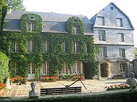
An old house in Le Havre, now Musée du Vieux Havre
|
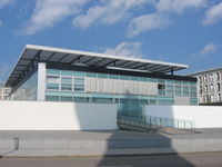
Musée des Beaux-Arts André Malraux, Le Havre
|
Downtown Le Havre
|
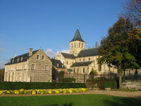
The Abbey of Graville, Le Havre
|
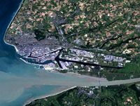
Le Havre/Seine/Honfleur
|
Le Havre was heavily bombed during the Second World War. Many historic buildings were lost as a result.
Churches
- Le Havre Cathedral : the first stone of the building was laid in 1536. It is the seat of the Bishop of Le Havre.
- Church of St. Joseph, one of the most recognized symbols of the city. The belltower is one of the tallest in France, rising to a height of 106 metres. It was designed by Auguste Perret.
- Church of St. Michel
- Church of St. Vincent [Eglise St. Vincent:[2]
- Church of St. François [Eglise St. François:[3]
- Church of St. Anne [Eglise St. Anne:[4]
- Church of St. Marie
- St. Michel d'Ingouville chapel (15th century) [St. Michel Chapel:[5]
- Graville Abbey, a monastery dedicated to Sainte Honorine, set in grounds on the northern bank of the Seine River.
- Presbyterian Reform Church (Eglise Réformée), 47 rue Anatole France, built in 1857, bombed in 1941, the roof and ceiling was rebuilt in 1953 by two architects of the famous Auguste Perret office: Jacques Lamy and Gérard Dupasquier, Only one building in the town offering both: ancient and new Perret school architectures in the same building. Holy Office each Sunday morning at 10.30.
Museums
- Musée des Beaux-Arts André Malraux : this museum houses a collection of art spanning the past five centuries, the impressionist paintings collections are the second most extensive in France after those of the Orsay Museum in Paris. There are paintings by Claude Monet and other artists who lived and worked in Normandy. Some of the paintings are from Eugène Boudin, Eugène Delacroix, Gustave Courbet, Edgar Degas, Édouard Manet, Pierre-Auguste Renoir, Georges Seurat, Raoul Dufy, Alfred Sisley. One of the museum's latest purchases is Vague, par temps d'orage by Gustave Courbet. The collection of Olivier Senn (1864–1959), given to the museum in 2004, contains more than 205 paintings.
- Musée du Vieux Havre
- Musée d'histoire naturelle (Museum of Natural History)
Others
- The Shipowner home (18th century)
- The former tribunal (18th century)
- The town Hall : the modern belfry contains offices
- The "Volcan", cultural center built by Oscar Niemeyer
- Square St. Roch
- Japanese Garden
Transportation
Le Havre has well developed national road, rail and air links (Octeville airport) and is two hours by train from Paris, with services running to the Gare du Havre. Local transport is based primarily on an extensive bus network. The city has plans for a tram network. A ferry service to Portsmouth in the United Kingdom runs from the Terminal de la Citadelle. The service is operated by LD Lines.
The Port of Le Havre is the largest deep water ocean port of France.
Sports
The town is home to the Le Havre AC football team, who as of 2009-10 play in Ligue 2, the 2nd tier of French football. It also hosted the sailing events for the 1900 and 1924 Summer Olympics, respectively.
Twin towns
Le Havre is twinned, or has a sister city relationship with:[3]
People
Le Havre was the birthplace of:
- Georges de Scudéry (1601–1667), novelist, dramatist and poet
- Madeleine de Scudéry (1607–1701), writer
- Jacques-Henri Bernardin de Saint-Pierre (1737–1814), writer and botanist
- Charles Alexandre Lesueur (1778–1846), naturalist, artist and explorer
- Casimir Delavigne (1793–1843), poet and dramatist
- Gabriel Monod (1844–1912), historian
- Louis Bachelier (1870–1946), mathematician
- Raoul Dufy (1877–1953), painter
- André Caplet (1878–1925), composer and conductor
- René Coty (1882–1962), French president (1954–1959)
- Arthur Honegger (1892–1955), composer, a member of Les Six
- Thomas Roberts (1893–1976), Roman Catholic archbishop
- Jean Dubuffet (1901–1985), artist
- Raymond Queneau (1903–1976), poet and novelist
- Jacques Leguerney (1906–1997), composer
- Tristan Murail (1947 - ), composer
- Laurent Ruquier (1963 - ), journalist
- Jérôme Le Banner (1972 - ), K-1 Fighter
- Olivier Durand (1967 - ), Guitarist for Elliott Murphy
- Eugenia DeLamare (1824–1907) - Guilherme Schüch - Wife - Baron Von Capanema
- Vikash Dhorasoo,(1973 -), International footballer
- Gueida Fofana,footballer
- Olivier Davidas,footballer
- Julien Faubert,footballer
- Fouleymata Camara,handball player
- Kevin Anin,footballer
References
Sources
Notes
External links
|
World Heritage Sites in France |
|
| Île-de-France |
|
 |
|
| Parisian basin |
|
|
| Nord-Pas-de-Calais |
Belfries of Belgium and France2 · Fortifications of Vauban1
|
|
| East |
Fortifications of Vauban1 · Great Saltworks of Salins-les-Bains and Royal Saltworks of Arc-et-Senans · Place Stanislas, Place de la Carrière and Place d'Alliance, Nancy · Strasbourg – Grande Île
|
|
| West |
Abbey Church of Saint-Savin-sur-Gartempe · Fortifications of Vauban1 · Loire Valley between Sully-sur-Loire and Chalonnes1 · Mont Saint-Michel and its Bay1 · Routes of Santiago de Compostela1
|
|
| South West |
Albi · Bordeaux · Canal du Midi1 · Fortifications of Vauban1 · Prehistoric Sites and Decorated Caves of the Vézère Valley · Pyrénées - Mont Perdu3 · Routes of Santiago de Compostela1 · Saint-Émilion
|
|
| Centre East |
Lyon · Routes of Santiago de Compostela1
|
|
| Mediterranean |
Arles, Roman and Romanesque Monuments · Canal du Midi1 · Carcassonne · Fortifications of Vauban1 · Gulf of Porto (Calanches de Piana • Gulf of Girolata • Scandola Reserve) · Papal Palace, Episcopal Ensemble and Avignon Bridge, Avignon · Pont du Gard · Roman Theatre and its Surroundings and Triumphal Arch of Orange · Routes of Santiago de Compostela1
|
|
Overseas departments
and territories |
Lagoons of New Caledonia · Pitons, cirques and remparts of Reunion Island
|
|
| 1 Shared with other region/s · 2 Shared locally with other region/s and with Belgium · 3 Shared with Spain |
|
|
Communes of the Seine-Maritime department |
|
Allouville-Bellefosse · Alvimare · Ambrumesnil · Amfreville-la-Mi-Voie · Amfreville-les-Champs · Anceaumeville · Ancourt · Ancourteville-sur-Héricourt · Ancretiéville-Saint-Victor · Ancretteville-sur-Mer · Angerville-Bailleul · Angerville-la-Martel · Angerville-l'Orcher · Angiens · Anglesqueville-l'Esneval · Anglesqueville-la-Bras-Long · Anneville-Ambourville · Anneville-sur-Scie · Annouville-Vilmesnil · Anquetierville · Anvéville · Ardouval · Argueil · Arques-la-Bataille · Assigny · Aubéguimont · Aubermesnil-aux-Érables · Aubermesnil-Beaumais · Auberville-la-Campagne · Auberville-la-Manuel · Auberville-la-Renault · Auffay · Aumale · Auppegard · Auquemesnil · Authieux-Ratiéville · Les Authieux-sur-le-Port-Saint-Ouen · Autigny · Autretot · Auvilliers · Auzebosc · Auzouville-Auberbosc · Auzouville-l'Esneval · Auzouville-sur-Ry · Auzouville-sur-Saâne · Avesnes-en-Bray · Avesnes-en-Val · Avremesnil · Bacqueville-en-Caux · Bailleul-Neuville · Baillolet · Bailly-en-Rivière · Baons-le-Comte · Bardouville · Barentin · Baromesnil · Bazinval · Beaubec-la-Rosière · Beaumont-le-Hareng · Beaurepaire · Beaussault · Beautot · Beauval-en-Caux · Beauvoir-en-Lyons · Bec-de-Mortagne · Belbeuf · Bellencombre · Bellengreville · Belleville-en-Caux · Belleville-sur-Mer · La Bellière · Belmesnil · Bénarville · Bénesville · Bennetot · Bénouville · Bermonville · Berneval-le-Grand · Bernières · Bertheauville · Bertreville · Bertreville-Saint-Ouen · Bertrimont · Berville · Berville-sur-Seine · Betteville · Beuzeville-la-Grenier · Beuzeville-la-Guérard · Beuzevillette · Bézancourt · Bierville · Bihorel · Biville-la-Baignarde · Biville-la-Rivière · Biville-sur-Mer · Blacqueville · Blainville-Crevon · Blangy-sur-Bresle · Blosseville · Le Bocasse · Bois-d'Ennebourg · Bois-Guilbert · Bois-Guillaume · Bois-Héroult · Bois-Himont · Bois-l'Évêque · Le Bois-Robert · Boissay · Bolbec · Bolleville · Bonsecours · Boos · Bordeaux-Saint-Clair · Bornambusc · Bosc-Bérenger · Bosc-Bordel · Bosc-Édeline · Bosc-Guérard-Saint-Adrien · Bosc-Hyons · Bosc-le-Hard · Bosc-Mesnil · Bosc-Roger-sur-Buchy · Bosville · Boudeville · Bouelles · La Bouille · Bourdainville · Le Bourg-Dun · Bourville · Bouville · Brachy · Bracquemont · Bracquetuit · Bradiancourt · Brametot · Bréauté · Brémontier-Merval · Bretteville-du-Grand-Caux · Bretteville-Saint-Laurent · Brunville · Buchy · Bully · Bures-en-Bray · Butot · Butot-Vénesville · Cailleville · Cailly · Callengeville · Calleville-les-Deux-Églises · Campneuseville · Canehan · Canouville · Canteleu · Canville-les-Deux-Églises · Cany-Barville · Carville-la-Folletière · Carville-Pot-de-Fer · Le Catelier · Catenay · Caudebec-en-Caux · Caudebec-lès-Elbeuf · Le Caule-Sainte-Beuve · Cauville-sur-Mer · Les Cent-Acres · La Cerlangue · La Chapelle-du-Bourgay · La Chapelle-Saint-Ouen · La Chapelle-sur-Dun · La Chaussée · Cideville · Clais · Clasville · Claville-Motteville · Cléon · Clères · Cleuville · Cléville · Cliponville · Colleville · Colmesnil-Manneville · Compainville · Conteville · Contremoulins · Cottévrard · Crasville-la-Mallet · Crasville-la-Rocquefort · Cressy · Criel-sur-Mer · La Crique · Criquebeuf-en-Caux · Criquetot-l'Esneval · Criquetot-le-Mauconduit · Criquetot-sur-Longueville · Criquetot-sur-Ouville · Criquiers · Critot · Croisy-sur-Andelle · Croixdalle · Croix-Mare · Cropus · Crosville-sur-Scie · Cuverville · Cuverville-sur-Yères · Cuy-Saint-Fiacre · Dampierre-en-Bray · Dampierre-Saint-Nicolas · Dancourt · Darnétal · Daubeuf-Serville · Dénestanville · Derchigny · Déville-lès-Rouen · Dieppe · Doudeauville · Doudeville · Douvrend · Drosay · Duclair · Écalles-Alix · Écrainville · Écretteville-lès-Baons · Écretteville-sur-Mer · Ectot-l'Auber · Ectot-lès-Baons · Elbeuf · Elbeuf-en-Bray · Elbeuf-sur-Andelle · Életot · Ellecourt · Émanville · Envermeu · Envronville · Épinay-sur-Duclair · Épouville · Épretot · Épreville · Ermenouville · Ernemont-la-Villette · Ernemont-sur-Buchy · Esclavelles · Eslettes · Esteville · Estouteville-Écalles · Étaimpuis · Étainhus · Étalleville · Étalondes · Étoutteville · Étretat · Eu · Fallencourt · Fauville-en-Caux · Fécamp · Ferrières-en-Bray · La Ferté-Saint-Samson · Fesques · La Feuillie · Flamanville · Flamets-Frétils · Flocques · La Folletière · Fongueusemare · Fontaine-en-Bray · Fontaine-la-Mallet · Fontaine-le-Bourg · Fontaine-le-Dun · Fontaine-sous-Préaux · La Fontelaye · Fontenay · Forges-les-Eaux · Le Fossé · Foucarmont · Foucart · Franqueville-Saint-Pierre · Fréauville · La Frénaye · Freneuse · Fresles · Fresnay-le-Long · Fresne-le-Plan · Fresnoy-Folny · Fresquiennes · Freulleville · Fréville · Frichemesnil · Froberville · Fry · Fultot · La Gaillarde · Gaillefontaine · Gainneville · Gancourt-Saint-Étienne · Ganzeville · Gerponville · Gerville · Glicourt · Goderville · Gommerville · Gonfreville-Caillot · Gonfreville-l'Orcher · Gonnetot · Gonneville-la-Mallet · Gonneville-sur-Scie · Gonzeville · Gouchaupre · Goupillières · Gournay-en-Bray · Gouy · Graimbouville · Grainville-la-Teinturière · Grainville-sur-Ry · Grainville-Ymauville · Grand-Camp · Grand-Couronne · Grandcourt · Les Grandes-Ventes · Le Grand-Quevilly · Graval · Grèges · Grémonville · Greny · Greuville · Grigneuseville · Gruchet-le-Valasse · Gruchet-Saint-Siméon · Grugny · Grumesnil · Guerville · Gueures · Gueutteville · Gueutteville-les-Grès · Guilmécourt · La Hallotière · Le Hanouard · Harcanville · Harfleur · Hattenville · Haucourt · Haudricourt · Haussez · Hautot-l'Auvray · Hautot-le-Vatois · Hautot-Saint-Sulpice · Hautot-sur-Mer · Hautot-sur-Seine · Le Havre · La Haye · Héberville · Hénouville · Héricourt-en-Caux · Hermanville · Hermeville · Le Héron · Héronchelles · Heugleville-sur-Scie · Heuqueville · Heurteauville · Hodeng-au-Bosc · Hodeng-Hodenger · Houdetot · Le Houlme · Houppeville · Houquetot · La Houssaye-Béranger · Hugleville-en-Caux · Les Ifs · Illois · Imbleville · Incheville · Ingouville · Intraville · Isneauville · Jumièges · Lamberville · Lammerville · Landes-Vieilles-et-Neuves · Lanquetot · Lestanville · Lillebonne · Limésy · Limpiville · Lindebeuf · Lintot · Lintot-les-Bois · Les Loges · La Londe · Londinières · Longmesnil · Longroy · Longueil · Longuerue · Longueville-sur-Scie · Louvetot · Lucy · Luneray · La Mailleraye-sur-Seine · Malaunay · Malleville-les-Grès · Manéglise · Manéhouville · Maniquerville · Manneville-ès-Plains · Manneville-la-Goupil · Mannevillette · Maromme · Marques · Martainville-Épreville · Martigny · Martin-Église · Massy · Mathonville · Maucomble · Maulévrier-Sainte-Gertrude · Mauny · Mauquenchy · Mélamare · Melleville · Ménerval · Ménonval · Mentheville · Mésangueville · Mesnières-en-Bray · Le Mesnil-Durdent · Le Mesnil-Esnard · Mesnil-Follemprise · Le Mesnil-Lieubray · Mesnil-Mauger · Mesnil-Panneville · Mesnil-Raoul · Le Mesnil-Réaume · Le Mesnil-sous-Jumièges · Meulers · Millebosc · Mirville · Molagnies · Monchaux-Soreng · Monchy-sur-Eu · Mont-Cauvaire · Mont-de-l'If · Mont-Saint-Aignan · Montérolier · Montigny · Montivilliers · Montmain · Montreuil-en-Caux · Montroty · Montville · Morgny-la-Pommeraye · Morienne · Mortemer · Morville-sur-Andelle · Motteville · Moulineaux · Muchedent · Nesle-Hodeng · Nesle-Normandeuse · Neufbosc · Neufchâtel-en-Bray · Neuf-Marché · La Neuville-Chant-d'Oisel · Neuville-Ferrières · Néville · Nointot · Nolléval · Normanville · Norville · Notre-Dame-d'Aliermont · Notre-Dame-de-Bliquetuit · Notre-Dame-de-Bondeville · Notre-Dame-de-Gravenchon · Notre-Dame-du-Bec · Notre-Dame-du-Parc · Nullemont · Ocqueville · Octeville-sur-Mer · Offranville · Oherville · Oissel · Omonville · Orival · Osmoy-Saint-Valery · Ouainville · Oudalle · Ourville-en-Caux · Ouville-l'Abbaye · Ouville-la-Rivière · Paluel · Parc-d'Anxtot · Pavilly · Penly · Petit-Couronne · Le Petit-Quevilly · Petiville · Pierrecourt · Pierrefiques · Pierreval · Pissy-Pôville · Pleine-Sève · Pommereux · Pommeréval · Ponts-et-Marais · La Poterie-Cap-d'Antifer · Préaux · Prétot-Vicquemare · Preuseville · Puisenval · Quevillon · Quévreville-la-Poterie · Quiberville · Quièvrecourt · Quincampoix · Raffetot · Rainfreville · Réalcamp · Rebets · La Remuée · Rétonval · Reuville · Ricarville · Ricarville-du-Val · Richemont · Rieux · Riville · Robertot · Rocquefort · Rocquemont · Rogerville · Rolleville · Roncherolles-en-Bray · Roncherolles-sur-le-Vivier · Ronchois · Rosay · Rouen · Roumare · Routes · Rouville · Rouvray-Catillon · Rouxmesnil-Bouteilles · Royville · La Rue-Saint-Pierre · Ry · Saâne-Saint-Just · Sahurs · Sainneville · Saint-Aignan-sur-Ry · Saint-André-sur-Cailly · Saint-Antoine-la-Forêt · Saint-Arnoult · Saint-Aubin-Celloville · Saint-Aubin-de-Crétot · Saint-Aubin-Épinay · Saint-Aubin-le-Cauf · Saint-Aubin-lès-Elbeuf · Saint-Aubin-Routot · Saint-Aubin-sur-Mer · Saint-Aubin-sur-Scie · Saint-Clair-sur-les-Monts · Saint-Crespin · Saint-Denis-d'Aclon · Saint-Denis-le-Thiboult · Saint-Denis-sur-Scie · Sainte-Adresse · Sainte-Agathe-d'Aliermont · Sainte-Austreberthe · Sainte-Beuve-en-Rivière · Sainte-Colombe · Sainte-Croix-sur-Buchy · Sainte-Foy · Sainte-Geneviève · Sainte-Hélène-Bondeville · Sainte-Marguerite-sur-Duclair · Sainte-Marguerite-sur-Fauville · Sainte-Marguerite-sur-Mer · Sainte-Marie-au-Bosc · Sainte-Marie-des-Champs · Saint-Étienne-du-Rouvray · Saint-Eustache-la-Forêt · Saint-Georges-sur-Fontaine · Saint-Germain-des-Essourts · Saint-Germain-d'Étables · Saint-Germain-sous-Cailly · Saint-Germain-sur-Eaulne · Saint-Gilles-de-Crétot · Saint-Gilles-de-la-Neuville · Saint-Hellier · Saint-Honoré · Saint-Jacques-d'Aliermont · Saint-Jacques-sur-Darnétal · Saint-Jean-de-Folleville · Saint-Jean-de-la-Neuville · Saint-Jean-du-Cardonnay · Saint-Jouin-Bruneval · Saint-Laurent-de-Brèvedent · Saint-Laurent-en-Caux · Saint-Léger-aux-Bois · Saint-Léger-du-Bourg-Denis · Saint-Léonard · Saint-Maclou-de-Folleville · Saint-Maclou-la-Brière · Saint-Mards · Saint-Martin-au-Bosc · Saint-Martin-aux-Arbres · Saint-Martin-aux-Buneaux · Saint-Martin-de-Boscherville · Saint-Martin-du-Bec · Saint-Martin-du-Manoir · Saint-Martin-du-Vivier · Saint-Martin-en-Campagne · Saint-Martin-le-Gaillard · Saint-Martin-l'Hortier · Saint-Martin-Osmonville · Saint-Maurice-d'Ételan · Saint-Michel-d'Halescourt · Saint-Nicolas-d'Aliermont · Saint-Nicolas-de-Bliquetuit · Saint-Nicolas-de-la-Haie · Saint-Nicolas-de-la-Taille · Saint-Ouen-du-Breuil · Saint-Ouen-le-Mauger · Saint-Ouen-sous-Bailly · Saint-Paër · Saint-Pierre-Bénouville · Saint-Pierre-de-Manneville · Saint-Pierre-des-Jonquières · Saint-Pierre-de-Varengeville · Saint-Pierre-en-Port · Saint-Pierre-en-Val · Saint-Pierre-Lavis · Saint-Pierre-lès-Elbeuf · Saint-Pierre-le-Vieux · Saint-Pierre-le-Viger · Saint-Quentin-au-Bosc · Saint-Rémy-Boscrocourt · Saint-Riquier-en-Rivière · Saint-Riquier-ès-Plains · Saint-Romain-de-Colbosc · Saint-Saëns · Saint-Saire · Saint-Sauveur-d'Émalleville · Saint-Sylvain · Saint-Vaast-d'Équiqueville · Saint-Vaast-Dieppedalle · Saint-Vaast-du-Val · Saint-Valery-en-Caux · Saint-Victor-l'Abbaye · Saint-Vigor-d'Ymonville · Saint-Vincent-Cramesnil · Saint-Wandrille-Rançon · Sandouville · Sassetot-le-Malgardé · Sassetot-le-Mauconduit · Sasseville · Sauchay · Saumont-la-Poterie · Sauqueville · Saussay · Sausseuzemare-en-Caux · Senneville-sur-Fécamp · Sept-Meules · Serqueux · Servaville-Salmonville · Sévis · Sierville · Sigy-en-Bray · Smermesnil · Sommery · Sommesnil · Sorquainville · Sotteville-lès-Rouen · Sotteville-sous-le-Val · Sotteville-sur-Mer · Tancarville · Thérouldeville · Theuville-aux-Maillots · Thiergeville · Thiétreville · Thil-Manneville · Le Thil-Riberpré · Thiouville · Le Tilleul · Tocqueville-en-Caux · Tocqueville-les-Murs · Tocqueville-sur-Eu · Torcy-le-Grand · Torcy-le-Petit · Le Torp-Mesnil · Tôtes · Touffreville-la-Cable · Touffreville-la-Corbeline · Touffreville-sur-Eu · Tourville-la-Chapelle · Tourville-la-Rivière · Tourville-les-Ifs · Tourville-sur-Arques · Toussaint · Le Trait · Trémauville · Le Tréport · La Trinité-du-Mont · Triquerville · Les Trois-Pierres · Trouville · Turretot · Val-de-la-Haye · Val-de-Saâne · Valliquerville · Valmont · Varengeville-sur-Mer · Varneville-Bretteville · Vassonville · Vatierville · Vattetot-sous-Beaumont · Vattetot-sur-Mer · Vatteville-la-Rue · La Vaupalière · Veauville-lès-Baons · Veauville-lès-Quelles · Vénestanville · Ventes-Saint-Rémy · Vergetot · Veules-les-Roses · Veulettes-sur-Mer · Vibeuf · Vieux-Manoir · Vieux-Rouen-sur-Bresle · La Vieux-Rue · Villainville · Villequier · Villers-Écalles · Villers-sous-Foucarmont · Villy-sur-Yères · Vinnemerville · Virville · Vittefleur · Wanchy-Capval · Yainville · Yébleron · Yerville · Ymare · Yport · Ypreville-Biville · Yquebeuf · Yvecrique · Yvetot · Yville-sur-Seine
|
|
|
Venues of the 1924 Summer Olympics |
|
Bagatelle · Bassin d'Argentuil · Camp de Châlons · Fontainebleau · Hippodrome d'Auteuil · Issy-les-Moulineaux · Le Havre · Le Stade Olympique Reims · Le Stand de Tir de Versailles · Meulan-en-Yvelines · Piscine des Tourelles · Saint-Cloud · Stade Bergeyre · Stade de Colombes · Stade de Paris · Stade Pershing · Vélodrome d'hiver
|
|
![[2]](http://catholique-lehavre.cef.fr/3_les_paroisses_du_diocese/3_23_sainte_therese_des_ponts_de_seine/3_23_1_images_sainte_therese_des_ponts_de_seine/Eglise St Vincent de St Vincent Cramesnil.JPG)
![[3]](http://catholique-lehavre.cef.fr/3_les_paroisses_du_diocese/3_21_saint_yves_de_la_mer/3_21_1_images_saint_yves_de_la_mer/Eglise St Fran�ois du Havre.JPG)
![[5]](http://catholique-lehavre.cef.fr/3_les_paroisses_du_diocese/3_21_saint_yves_de_la_mer/3_21_1_images_saint_yves_de_la_mer/Chapelle St Michel d'Ingouville au Havre.JPG)